The essence of this procedure is to divide one plot into two or more parts , with each part acting as a separate plot with its own unique cadastral number and address assigned to it.
Goals of the procedure
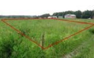
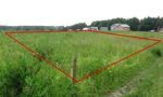
The survey carried out consists of creating a plan that will include a drawing diagram of the land plot and precise indications of the coordinates of the boundaries with a detailed description of its characteristic features.
During the land surveying process, an application is submitted from the owner of the site or its user , while the site itself, after the entire process, can change its outline or configuration only in situations where the boundaries are clarified and agreed upon with cadastral engineers.
In contrast to such a process, demarcation is somewhat different from land surveying. This procedure involves dividing the plot into two or more parts and clearly establishing the boundaries of subsequent possessions.
Such actions may occur in the following situations :
- If there is a need to sell part of one plot owned by the owner;
- If it is necessary to divide property , when such measures take place during the divorce of spouses and the division of property that belongs to jointly acquired property. Moreover, most often such measures are applied to those areas that do not yet have buildings on their territory.
This may also be required:
- If it is necessary to change the intended use of part of the land . In this case, one of these parts can remain at its previous purpose, and the second, after the process of allocation and drawing up a boundary plan, can change it;
- The site initially had several owners , who, during its operation, decided to legally allocate a share and further use it as a separate plot.
How to differentiate between two owners
The procedure for surveying and delimiting land plots between two or more owners is determined by Articles 11.2 and 11.4 of the Land Code of the Russian Federation, which directly indicate the possibility of such action in the process of carrying out cadastral work by an engineer and determining clear boundaries of the site.
If there is a need to divide land plots, the indicators of the minimum permissible area must be taken into account .
In the event that any share does not fall under the existing requirements after the division, the delimitation procedure will not be able to be carried out.
Even if the cadastral engineer takes such action and prepares a boundary plan, in any case the owner of the plot will be faced with the impossibility of registering ownership.
The first stage of demarcation is drawing up an agreement on the division of property. Such a clause must be present only in situations where the owners of individual shares of the plot will be different entities or persons .
The agreement must be drawn up in writing and signed by all interested parties - only in this case can we begin to delineate the site and subsequently allocate two or more independent cadastral units.
The agreement itself necessarily reflects that the owners of the plot independently decided to divide it , indicate information about its owners, as well as information that such a decision is voluntary and mutual.
Situations often arise in which one of the owners, for some reason, does not agree with the separation procedure. In such a situation, it is possible to go to court (magistrate or district).
In this case, an important point is the determination of jurisdiction - if the cost of the claim is up to 50 thousand rubles, the application is submitted to the magistrate’s court , if more, then to the district court .
Selecting a contractor
Once all legal issues have been resolved, the next step is to select a contractor who will carry out the work.
- At the same time, the cadastral engineer authorized to draw up a boundary plan must have a license to perform such work , which the customer has the right to demand for presentation before directly executing the contract for the provision of services.
- Additionally, you can check the availability of qualifications on the Rosreestr website, which contains data on all specialists of the Russian Federation who currently have valid licenses .
- Also on the portal you can additionally obtain information about the availability of boundary plans from a specific specialist, which for certain reasons were declared invalid.
Survey work
- In the process of directly carrying out boundary work, the cadastral engineer requests from the customer all the necessary information on the site and, first of all, analyzes the data regarding the passage of the boundaries of the site and its turning points.
- Subsequently, based on how the owners (or one owner) intend to divide the plot, the coordinates of new boundaries are calculated, which will define individual land plots.
- A land surveying project is drawn up and a cadastral engineer must go to its location to draw the boundaries in kind and obtain the signatures of interested parties , which will confirm their agreement with how the new boundaries will be laid.
Planning
In the process of drawing up a boundary plan, the cadastral engineer will primarily be guided by the data obtained by directly determining the boundaries of the divided plot or those plots that adjoin it.
- If the coordinates of any points raise doubts about their accuracy or validity, additional calculations are made , which subsequently must also be based on the nature and location of the plots, as well as the distinctive features of the landscape or territory.
- The boundaries determined by a specialist are expressed in the exact coordinates of turning points, between which lines are drawn, which subsequently define individual areas with different cadastral numbers.
- The passport itself must display a diagram (drawing) of the site plan, and also provide the values of the boundary coordinates.
Assigning addresses to adjacent shares
- After the boundary files regarding the divided plots have been prepared, the following mandatory procedure will need to be carried out - assigning addresses to the newly formed plots.
- To carry out such an action, you will need to contact the local government authority .
- To do this, the owner (or owners) can submit applications in person, submit documents to the MFC, or use the help of an authorized representative (if there is a separate power of attorney certified by a notary).
- You can also fill out an electronic application through one of the Russian portals that provide such services.
- After the application reaches the specialists of the authorized body, a decision is made within 18 days to assign individual addresses or to refuse such an action based on the provisions of the law.
- The readiness of the boundary plan and the address assigned to the plot give the right to register ownership, since such a procedure is necessary for the possibility of carrying out legal actions with the plots.
Simultaneously with this action, the old plot that was divided is removed from cadastral registration .
In order to register rights to newly formed plots, you will need to contact Rosreestr and provide the following documentation :
- Owner's passport;
- Application for registration;
- Agreement between the owners of the site on the demarcation procedure. In its absence, a court decision is provided;
- Power of attorney, if the application is submitted by a representative of the owner;
- A receipt confirming payment of the state fee.
Differences from the usual procedure
Sometimes it becomes necessary to carry out a land surveying procedure for those plots that are in shared ownership.
In such a situation, the course of the process will be almost similar to land surveying on a general basis and is as follows :
- Contact a cadastral engineer. In such situations, it will be necessary to obtain consent to determine the boundaries from all persons who have a share in the common property;
- Carrying out work directly by a cadastral engineer, during which the coordinates of the boundaries of the site are determined and the resulting boundaries are drawn into nature;
- Coordination of established boundaries with all owners of adjacent plots, as well as persons owning a share of the plot;
- Drawing up a boundary plan that is common to the site and can be used by each of the shareholders.
Features of share surveying
During the demarcation process, one of the future owners may need to clearly define the boundaries of the newly formed site, but the other may not. In such situations, the work carried out will in any case require written consent to divide the site, but the boundary plan itself will be drawn up only for a portion of the site .
In the future, the owner may encounter a problem when registering the cadastral register , since there is a parallel deregistration of the old plot.
Adjacent plots
In such a situation, it is necessary to understand that the owners will not be able to save money - the work for each site will be accompanied by the conclusion of a separate agreement between the owner and the geodetic organization.
The result of land surveying is drawn up boundary plans - separate documents showing the drawings of each site.
Conclusion
So, land surveying and delimitation of plots is a procedure that consists of determining the coordinates of the boundaries of plots and placing them on the ground .
When delimiting plots, a distinctive feature will be the division of one entire plot into two or more, the subsequent assignment of separate addresses and ownership of each allocated unit.
- In contact with
- Google+
- Classmates
- My world
Land surveying of a shared land plot as a process of registration of ownership rights
Landowners of common shared land often want to manage only their part of the land. Nowadays, this need can be fulfilled with the help of the land code through land surveying.
- It states that in case of misunderstanding and failure to find a common scheme for solving problems for all owners of rights to a share, each participant can re-register the land plot from common ownership to individual ownership.
- The delineation of common land is carried out in order to allocate a share of the main territory and at the same time secure the right of individual ownership to the owner.
- To obtain individual property rights, you need to understand that there are two different types of joint ownership:
- Joint (common) ownership without dividing the land into smaller parts for each owner;
- Collective shared ownership with a fixed share for each copyright holder.
In the first case, there is usually an oral agreement between all owners of the common land. This agreement discusses the responsibilities and procedures for using the territory for all its owners. Conditional boundaries may be drawn on common land, but they will not have legal force.
In the second option, the measure of right is determined for each owner who received a share from the shared land plot. Such land is divided by surveying both the entire territory and a separate share of one owner.
Where to begin
Land demarcation of common shared ownership is a process of acquiring autonomy and a new legal status. This process is carried out by identifying boundaries on the ground and in project documentation. A shared land plot can be divided equally among all owners or not.
It is possible to allocate part of the territory as a share in accordance with the size of the property right. In cases where all owners of a shared land plot want to allocate their shares, they should all jointly contact a geodetic company. But before that, you should go to the administration and find out the rules for allocating a land plot.
The allocated share should not be less than or exceed the established standards. If this is not done, then otherwise your share will not fit into the established standards, which will subsequently lead to the refusal of further registration of rights.
You need to know that the duties of a cadastral engineer do not include consultation on this issue. He must carry out the work in accordance with your application, and not with the regulations of the municipality. The engineer will review the existing title documents and check on the map possible options for surveying the common land.
It is worth noting that if one of the parts of the shared land plot does not comply with the standards, the decree for cadastral registration will be denied to all land owners.
So you need to find out the norms for the share area before contacting a surveying company. In cases where only one owner of a share intends to carry out land surveying, he will need written permission from the other co-owners of the common land.
Cost of work
Estimating the cost of surveying is based on a number of factors:
- the price of land in the general area;
- the cost of geodetic services in a given region;
- status of the company that provides services;
- land area;
- status of the territory in which the share is located (regional center, district center, etc.);
- in some cases, the cost of work also includes the cost of transportation costs.
The cost of surveying is quite high. Agricultural land is valued lower than other categories of land.
After clarifying the standards, you need to contact a geodetic company, pay for the services and provide them with the necessary documents. Next, surveyors will create a plan - a diagram based on the available data, and only after that they will go to the area and carry out work in accordance with your application.
Requirements for surveying
Land surveying has a number of its own requirements, without which it cannot be carried out:
- all areas must have access (exit) to a public road;
- areas must be of the correct shape;
- lots should not overlap with adjacent lands.
Setting Boundaries
The result of land surveying will be clearly established the boundaries of the plots. As a result of the work, engineers will carry out a geodetic survey of the shared plot, check its compliance with established standards, and then begin dividing the territory into the desired shares. They will establish legal boundaries that will separate the new areas that have arisen.
These boundaries will state the ownership of each allocated portion, and exercise ownership of the land within certain boundaries. During the work, engineers fix new boundaries, which must correspond to the land survey plan and are established with sufficient accuracy.
Initially, the boundaries of the shared plot are established with temporary wooden or plastic pegs, and after completion of the work they are permanently secured by concreting the main boundary points.
Boundary signs are protected by law, which means that the owner of the land or other people do not have the right to move them, much less destroy them. Boundaries have legal force and are confirmation of boundary work.
Registration of land rights
Once you have been allocated part of your share and the proper boundaries have been determined, all you have to do is register your ownership at the local cadastre and cartography office. To do this you need to obtain the following documents:
- the act of agreeing on boundaries with neighbors;
- permission to separate land from former co-owners;
- land surveying project;
- act on the establishment of boundary signs.
With these documents you need to go to the cadastre and cartography department and register the land.
Then, having received the cadastral passport, collect a new package of documents for property registration:
- title document;
- cadastral passport of the land plot;
- act on the establishment of boundary signs.
With these documents and your passport, you can continue registering your property rights. Please note that after the land has been allocated, you only have the title document for the old share. For a new plot of land, confirmation of ownership will be an act of land surveying (installation of boundary markers).
The title you receive will not reflect legal precedent. Therefore, in the event of allocating a share from the common shared property, the survey document you received from a geodetic company will perform several important functions:
- determine the conditions for establishing (emerging) the right of ownership and use of the site;
- will give complete technical characteristics of the territory;
- will protect your land from outside attacks.
The deadlines for carrying out the work are negotiated with geodetic companies and are approximately equal to 15 calendar days, but are often completed faster. However, if you are put in a queue, it will definitely take extra time. An act of coordinating boundaries with neighbors can be drawn up and signed almost in one day.
Allocation and surveying of a share of a land plot from common shared ownership
The content of the article:
Allocation of a share from common property: features of the land surveying procedure
Civil legislation provides for the delimitation of ownership rights to:
1. Absolute.
2. Share.
3. General joint.
Each of these species has its own distinctive characteristics and characteristics. It is necessary to understand in more detail the characteristics of shared ownership, which implies the allocation to each of the participants of their part of the property and joint ownership.
Particular attention should be paid to individual legislative acts regulating land use for objects of various purposes. So, for example, the division of land from agricultural use can only occur when its intended purpose does not change and when the newly created plot meets size standards.
Lands of specially protected areas and reserve lands cannot be separated. Moreover, their transfer to private hands is not allowed, except in cases where its intended purpose has been changed in accordance with the procedure established by law.
Land surveying is a procedure that involves the determination of land boundaries, their identification in spatial planes, as well as their subsequent legal consolidation. Land surveying of a shared land plot can only be carried out by accredited engineers who have a license to carry out these types of work.
The end of land surveying is the issuance of a special act - a land survey plan.
The allocation of a share can occur if one of the following conditions is met:
- voluntary consent of participants in shared ownership;
- decision of a court or other government authority.
The allocation of a share is not always possible, therefore, when making such a decision, it is necessary to take into account the requirements of modern legislation regulating land legal relations.
In a situation where the allocation occurs voluntarily, the citizen must write a written application and submit it to the local municipality. Based on the results of consideration of this document, a decision is made. All expenses for the allocation of a share are paid by the citizen who initiated this process.
The exact price can only be announced after the work has been agreed upon with cadastre specialists. This is due to the fact that the price of surveying a share of a land plot and the allocation of a share as a whole depends directly on the cost of the land. You can determine what elements make up the price.
Is it possible to sell a plot of land without land surveying?
What determines the cost of land surveying:
- The cost of the site itself.
- Plot size.
- The price for land surveying applied by a specific cadastral engineer.
- The purpose of the land (agricultural, private plots, individual housing construction) and the status of the locality where it is located (city, village, etc.).
Allocation of a share is a rather costly and time-consuming procedure.
Land survey price for a share of a plot
As noted earlier, it is quite difficult to name the exact price of land surveying, since it depends on a large number of factors. Land surveying of a land plot that is in shared ownership, for example, in Moscow, will cost approximately 100,000 rubles.
In more remote regions the cost will be less.
Delimiting a large plot of land will cost much more than carrying out this procedure with a share. One way or another, the cost of just determining the boundaries can cost 15-20 thousand rubles.
In a situation where joint ownership of land in shared ownership is not possible and there is no agreed will of all participants, division can be carried out through the court.
To do this, you need to write a statement of claim and demand forced division. All costs of surveying can be divided between the participants in the process. When filing an application with the court, you need to remember the obligation to pay the state fee. The legal process for the division of land cannot exceed two months.
In case of allocation of a share on a voluntary basis, everything is based on the citizen’s application. It is submitted to the local administration. After obtaining permission, the necessary land surveying procedures are carried out, and the newly created land plot is registered.
In this situation, the list of documents is quite narrow. This includes:
- Boundary plan of the entire site.
- Certificate of cadastral value.
- Extract from the Unified State Register of Real Estate.
- Citizen's statement.
- His identification document.
- Court decision (if any).
All documents must be provided in original form. Copies are not permitted. In a situation where the division occurs with the help of a citizen’s representative, you must also provide a notarized power of attorney or a document confirming legal representation.
Land surveying according to the new law
The delineation of a land plot in shared ownership occurs in several stages, each of which has its own significant features. Among them are:
- Concluding an agreement with a surveying company.
- An engineer will visit to determine the boundaries of the land.
- Selecting coordinate points in different planes.
- Determination of area.
- Documentary recording of the results obtained.
- Legal registration.
As for determining boundaries, it can be carried out both in real time and with the help of maps and cartographic plans. This is one of the main stages of the land surveying procedure, which allows you to determine the area of land.
After land surveying of a land plot of common shared ownership has taken place, it is necessary to formalize this procedure legally and competently. This design occurs in two ways:
- By contacting the multifunctional center.
- By contacting the Rosreestr.
In both the first and second cases, the citizen must provide a package of documents, which includes:
- Land survey plan (it is submitted both on paper and on disk).
- Documents for land.
- Passport.
- Power of attorney (if the person acts under it).
You will have to pay a state fee to register your right. Its size is determined according to the rules provided for by tax legislation.
After checking the entire provided documentary base regarding the surveying of a common land plot, information about the owner of the newly created land plot is entered into the unified state register of rights to real estate. Due to recent reforms, certificates of ownership are no longer issued to citizens. Therefore, if necessary, they can order an extract from the Unified State Register. It will cost 400 rubles per piece.
Land surveying can be invalidated in the following situations:
- There was an overlap of boundaries.
- The survey was carried out using a forged power of attorney.
- There was forgery of documents.
- If the survey was carried out in violation of the rules of modern legislation.
The result of land surveying can be declared invalid only through the court. To do this, you need to file a claim to invalidate the land survey. The procedure for considering the case takes place within a period not exceeding two months. It is also necessary to pay a state fee.
Challenging the cadastral value of a land plot or real estate property
Both individuals and government agencies and surveying companies can be named as defendants.
A court decision made on this issue may be the basis for making changes to the unified state register of real estate and deleting records of land ownership.
Information about the newly formed land may also be cancelled. It can return to the boundaries of the previously existing land plot.
There are several reasons for which the allocation of a share in kind is impossible:
- When the rights and legitimate interests of other persons are violated.
- When the site being formed does not correspond to the legally established dimensions established by law.
- When a change in land category occurs.
- When will the imposition of boundaries on state infrastructure facilities, etc. take place?
Separate federal laws may provide for other reasons. For example, the Federal Law “On Agricultural Land” stipulates that the resulting plot cannot be less than two hectares.
It is also impossible to make a division when there are unregistered buildings on the boundaries of the plots. In this situation, it is first necessary to register them, and then carry out boundary work with the land.
Interesting Facts
- For the first time, such a concept as “land surveying” was introduced in 2001 by Federal Law No. 136. Previously, the procedure was regulated by boundary rules.
- Lands were divided back in the Russian Empire. There were several types of procedures: patrimonial, general, guardianship, etc.
- Of particular interest is the provision according to which moments arise when it is impossible to establish under what circumstances the land was transferred to a citizen before the Land Code of the Russian Federation was put into effect. The rule applied here is that the land owned by a citizen will belong to him by right of ownership, about which a corresponding note is made in the unified state real estate register. After this, you can make a division within the framework of land surveying.
Land surveying of apartment buildings
Why do they demarcate the land of apartment buildings and how to do it in the Moscow region
Have you ever thought about the fact that you need to survey the land under the apartment building in which you live and its surrounding area? No? Then this article is for you. We will tell you what opportunities the owners of land in an apartment building have, how to register a plot of land, and what problems the owner may encounter.
Why is land under an apartment building registered as ownership?
What is an apartment building? These are not only apartments in it, but also entrances, roofs, attics, basements, walls, the ground on which it stands, as well as parking, a playground, flower beds and much more. Apartment owners have full rights to use this property, but are not its owners.
That is, they cannot rent out, sell or convert at their discretion. In order to legally carry out transactions and dispose of common property, it is necessary to register it as property. It is registered as common property with all apartment owners.
Only then do owners have new opportunities.
Until you register ownership of the land under the apartment building, this property is managed by the state. Don't be surprised if your parking lot is given to a tenant, for example.
Let's look at the opportunities that apartment owners who have registered ownership of the land in an apartment building have.
- They have the right to decide what to do with their land or other real estate located on it. Therefore, they can rent out a plot, a basement or even a wall for an advertising space, design a parking lot or a children’s playground, redesign the sidewalks in the yard, install a barrier, and so on. Moreover, all actions must not contradict the law.
- It is no secret that the municipality gives land to developers. Buildings may appear on areas that could become playgrounds or recreational areas. Owners can prohibit infill development near their home. Agree, an important detail for the Moscow region!
- Another argument in favor of property for owners of Khrushchev apartments. If you are the full owner of land and other common property, then during the housing renovation program you will be compensated not only for the apartment, but also for all other property, i.e. cost of the plot.
“If the land is registered as shared ownership of the residents of an apartment building included in the housing renovation program, then there are grounds to raise the issue of payment of appropriate compensation in the event of seizure of the land plot for state needs,” writes the Federal Service for State Registration, Cadastre and Cartography (https: //rosreestr.ru/site/press/news/svoya-moskva-kak-oformit-zemlyu-pod-mnogokvartirnym-domom-v-sobstvennost/).
By the way, owners of apartments in houses adjacent to Khrushchev-era buildings should also demarcate the site so that when the houses are demolished, your piece of land will not be appropriated by developers.
- An unregistered local area is the reason for the refusal of the entire house to participate in the overhaul program.
- If you are a participant in shared construction, then you need to survey the land under your future home. If construction is not completed, the owners retain the right to the land and the unfinished construction.
Remember that in addition to opportunities, owners also have responsibilities regarding the maintenance of common property.
How to register real estate in a multi-apartment residential building (MCD)
In reality, there can be two situations - when the area under the house and the adjacent territory are demarcated, and cases in which demarcation has not been carried out.
Land delineation is the division of territory into sections in shares and the establishment of the boundaries of each section. Land surveying is necessary so that the owners know the exact boundaries of the property. Only after surveying can land ownership be registered.
Therefore, first of all, we need to find out whether a land plot has been formed for an apartment building. To do this, we check it using the public cadastral map.
- Enter the cadastral number of the plot on the Rosreestr website - rosreestr.ru to obtain information about it.
- pay the state fee of 600 rubles
- receive an extract with a passport and a certificate of ownership of residential or non-residential premises in this house.
- with the state duty, documents, contact the Center for the provision of public services “My Documents”. An extract on the right to a share in the common property of a plot is made within three days.
- If the area is not formed, then:
- Residents themselves are responsible for registering land rights.
- it is necessary to organize a meeting of the owners of the house, at which they decide how the site will be surveyed.
- enter into an agreement with a cadastral engineer, who will prepare a land surveying project and coordinate boundaries with the owners of neighboring lands or with the municipality. The boundary plan is approved by the Moscow City Property Department and submitted to public hearings, at which the owners of the apartment complex approve the project.
*The technical plan is prepared in the form of an electronic document and must be certified by an enhanced electronic signature of the cadastral engineer.
- appoint a representative who will fill out the application and submit a package of documents to Rosreestr. As a rule, this is the chairman of the house.
Important!
Residents of Moscow or New Moscow, when searching for a site, should pay attention to the accuracy with which the coordinates of the site boundaries are determined . They must correspond to the value of 0.1 meter. If the accuracy is different or has not been established, then it is impossible to carry out a merger, distribution, or allocation of shares.
*The accuracy of the plot can be found out from the cadastral extract for the land plot, which is ordered from Rosreestr.
Documents required for registration of rights to a plot under an apartment building.
- — application for state cadastral registration and state registration of the right of common shared ownership of common property in the apartment building;
- — the applicant’s passport (if an authorized person, then a notarized power of attorney);
- — decision of the general meeting of owners of the apartment building on land surveying of the house;
- — decision of the general meeting to determine each share in the common shared ownership;
- — boundary plan, design documentation, floor plan, decision to put the house into operation and other documents on the formation of the land plot on which the house is located;
- - documents confirming the rights of owners;
The collected documents must be submitted to the “My Documents” centers or to the reception offices of Rosreestr, or electronically through the Rosreestr portal. Registration period is 7-9 working days.
All real estate objects located on the territory of the MKZh house site are separated separately (apartments, parking spaces, pits, garages). We wrote about how to register ownership of a parking space here https://prokadastr.com/oformljaem-mashino-mesto-v-sobstvennost/
What difficulties can you encounter when surveying land under an apartment building?
- Reducing the area of the house is when your neighbors or the municipality appropriated a piece of your land. The problem is resolved in court. Before the process, obtain a certificate from Rosreestr about the actual size of the plot. If there is an error in the documents, contact a cadastral engineer to resolve it.
- If illegal real estate objects appeared on the site before land surveying, then the issue of their demolition must be resolved.
- If the owner of the constructed property leased your land from the municipality, then you will have to challenge the administration’s right to receive payment for the use of someone else’s land.
- If part of the land is already registered in someone’s name, and all permitting documents are available, then a land management examination should be carried out. According to the standards prescribed in SNiP, the adjacent territory should be only in the possession of the owners of apartment buildings.
Cadastral engineers of the Central Cadastral Bureau draw up boundary plans and perform all types of work to survey the territory of an apartment building.
You can order only land surveying and deal with the paperwork yourself, or use a comprehensive service for registration of apartment buildings and territory as property. Please call for pricing and timing +7 (499) 350-80-89.
Articles
" Back
Pillars and boundaries: how to properly survey a plot of land. 06.11.2013 12:03
Many summer residents are familiar with first-hand disputes arising from the definition of the boundaries of a land plot, or, simply put, from the dubious location of a neighbor’s fence.
Often, unlucky owners of land plots are forced to defend their innocence with rulers in their hands. However, there are more serious reasons for land surveying than “an extra 20 centimeters from the neighbor’s utility block.” This material is about in what cases land surveying is required, what opportunities this procedure opens up and how to carry it out correctly.
Land surveying includes a set of works to establish, restore and secure the boundaries of a land plot on the ground, determine its location and area.
Land surveying includes both technical and legal procedures, as a result of which the boundaries (coordinates of boundaries) of land holdings are determined and approved through special acts and signs.
Land surveying, as a rule, is carried out when forming a new plot (for example, when providing a citizen with a plot of municipal land or when dividing a plot) or in order to clarify the boundaries of an existing plot.
Typically, areas require land surveying for less pleasant, but more prosaic reasons.
For example, land surveying is necessary if the joint use of plots formed from one plot (for example, when inheriting a family estate) does not suit the new owners.
Land surveying is also required if the location or boundaries of the land plot are not specifically defined. Old certificates of land ownership very often did not indicate the exact address of the plot (for example, “740 meters southeast of residential building number 9 in the village of Khrushchevo”) and its exact measurement (for example, “20 by 30 meters with a total area of 600 square meters) .
meters"), and the new state cadastre may not contain old information about the boundaries of the land plot. As a result, it turns out that the only evidence of the owner’s rights is the fence, but you cannot bring it to court.
There are also situations when, over time, a land plot acquires a complex shape, which makes it impossible to determine its area without special measurements. For example, the neighbors changed the boundaries on one side of the site, on the other side a highway began to pass, and on the third, a young forest grew, becoming a full-fledged forest land. In such a situation of “invasion” of the site, it is better to demarcate it.
In fact, land surveying is also necessary to carry out legal transactions with the site - transfer by inheritance, sale, exchange, rental and others.
If land surveying is not carried out, then in the cadastral passport of the plot in the special marks column it will be written “the boundary of the land plot is not established in accordance with the requirements of land legislation.”
No violation of the law follows from this phrase - there is a site, and there are its borders - but for some officials this may be a good reason to create obstacles when processing transactions.
If we continue the conversation about casuistry, then the cadastral chamber may write in the plan issued that the land cadastre does not contain information that allows one to unambiguously identify the land plot.”
In such a situation, the purchase and sale agreement is also unlikely to be registered with the justice institution for state registration of rights to real estate, since in accordance with Article 554 of the Civil Code of the Russian Federation, the agreement must clearly define (describe) the property being sold. Land surveying is actually the physical definition of the object of sale.
In general, land surveying is a modern geodetic method of determining the boundaries of a land plot in a horizontal plane, as a result of which the owner receives electronic coordinates of the corner points of his plot, which looks much more convincing than measuring a fence with tape measures.
Issue price and document flow.
The cost of surveying a standard plot of land with an area of six to ten acres in the Moscow region is approximately 10-15 thousand rubles, and the time frame for such work is from one to three months. The production of a cadastral passport usually takes three or four weeks from the date of submission of the boundary plan.
To carry out surveying, the owner of a land plot must enter into an agreement with a specialized land management organization and prepare a package of documents that includes a title document (certificate of land ownership, resolution on the provision of a land plot, certificate of inheritance, judicial act establishing rights to a land plot ), a copy of the passport of the owner of the land plot, a power of attorney from an authorized representative (if the documents are provided by an authorized person). The remaining documents are prepared by the land management organization.
- Process and result.
- Land surveying includes a number of works performed by a specialized land management organization. These works include:
- — Collection and study of information from the state land cadastre about the site, documents confirming land rights, initial geodetic data, addresses of owners of adjacent plots;
- — Drawing up a technical project, which is drawn up in accordance with the assignment for land surveying;
- — Notification of persons whose rights may be affected during land surveying;
- — Determination of the boundaries of the land management object on the ground (the boundaries of the site are measured either from previously preserved plans and drawings, if there are none, then from the words of the owner of the site), their approval is prepared by an act of coordination of boundaries with neighbors) and secured with boundary signs;
- — Geodetic survey, determination of coordinates of boundary markers;
- — Determination of the area of the land management object;
- — Drawing up a map (plan) of a land management object or a map (plan) of the boundaries of a land management object;
- — Formation of a boundary plan.
As a result of carrying out land management work on surveying a land plot, the owner must receive a survey plan in electronic form on a CD; at the owner’s request, a survey plan on paper is issued. The boundary plan is submitted to the Rosreestr department, after which a cadastral passport is issued, which determines that the site is registered in the cadastral register and has specified (determined with geodetic accuracy) boundaries.
Does the law oblige land surveying?, administration of the Pyatizbyansky rural settlement
Recently, owners have been very concerned about the need to survey the land plots they own and whether it is possible to dispose of the land plot if the boundary of such a land plot has not been established.
The Office of Rosreestr for the Volgograd Region considers it necessary to re-explain this issue and, in particular, the consequences of the absence of boundaries established in accordance with the law at the site.
Today, relations arising during the implementation of state cadastral registration are regulated by the Federal Law of July 13, 2015 No. 218-FZ “On State Registration of Real Estate”.
Neither the said law nor other regulations prohibit the disposal of land plots whose boundaries are not in the Unified State Register of Real Estate (USRN).
This means that no one can limit the rights holders' disposal of such areas.
At the same time, there are situations when information about the location of the boundaries of land plots is entered into the Unified State Register of Real Estate with insufficient accuracy or is missing (for example, for previously registered land plots). The lack of information about boundaries in the Unified State Register of Real Estate gives rise to conflict situations and legal disputes between the owners of neighboring (adjacent) land plots.
When purchasing a plot of land without clear boundaries, the future owner is forced to trust the seller, who has his own vision of the boundary of the plot. In connection with this, it carries a certain risk: it may turn out that the buildings that you purchased along with the plot and consider to be yours are partially or completely located within the boundaries of a neighboring plot of land.
In this regard, the Office of Rosreestr for the Volgograd Region recommends protecting yourself from such problems in advance and establishing the boundaries of the site in coordinates.
An additional advantage for owners in the case of establishing boundaries will be that from the moment information about the coordinates of the boundaries of the land plot is entered into the Unified State Register, information about it will be displayed on such an information resource of Rosreestr as the “Public Cadastral Map”.
To establish the coordinates of the boundaries of a land plot on the ground and carry out boundary work, you must contact a cadastral engineer or technical inventory authorities. Based on the results of the work, a boundary plan is prepared, which must be submitted to the rights registration authority to clarify the boundaries of the land plot in the area.
The period for providing such a service in Rosreestr is 5 working days when submitting documents through registration authorities, or 7 working days when submitting documents through the MFC. There is no state fee for these actions.
Deputy Head of the Department for Registration of Non-Residential Real Estate of the Rosreestr Office for the Volgograd Region Panin Yuri Erlenovich
Land marking under the house
The delineation of a plot of land under an apartment building makes it possible to legally secure your right to land areas located under a residential building.
Very often, such a need arises both for individuals and their representatives (homeowners’ associations).
However, it is very difficult to carry out land surveying of built-up areas on your own, since the process of surveying such areas includes a large complex of land management work, the main purpose of which is the initial establishment of land ownership boundaries.
The land plot on which the apartment building and other real estate objects assigned to it are located, by virtue of the Federal Law of December 29, 2004 No. 189-FZ “On the entry into force of the Housing Code of the Russian Federation,” is the property of all owners of the premises in this apartment building.
But, in order to secure this right, it is necessary that the land plot be formed, i.e. a survey of the area under the apartment building must be carried out.
"Guild of Engineers" offers its clients a comprehensive implementation of all these and other necessary cadastral works in a qualified manner and within a reasonable time frame.
Basic work on surveying built-up areas
Owners of apartments in an apartment building in most cases try to document their rights of shared ownership of the plot under the house, taking into account the fact that the plot becomes their property completely free of charge. This procedure is very complex and requires certain knowledge and patience.
The most common problems in this procedure are as follows:
- The plot on which the apartment building is located was formed before the Housing Code of the Russian Federation came into force, but the issuance of a cadastral passport for this plot is refused due to crossing borders or is issued with a note about the need to clarify the boundaries when carrying out cadastral work. In this case, it is necessary to carry out land surveying of the land plot of an apartment building , which only cadastral engineers have the right to carry out.
- The site on which the apartment building is located has not been formed. Here the situation is more complicated and cannot be done without the help of specialists. To form a land plot, it is necessary to hold a meeting of all owners of premises in order to select a person who must apply to the state authorities for the formation of a land plot. In turn, government bodies issue only an administrative document on the formation of a site, while carrying out land surveying under an apartment building falls on the shoulders of the owners of the premises. In most cases, taking into account the absence of visits by a representative of government agencies directly to the territory, these administrative documents contain errors in the location of the border, which are identified directly in the process of surveying the land under the house .
To avoid making mistakes in documents and wasting your nerves and energy fighting the bureaucracy, we recommend contacting qualified specialists, such as the Guild of Engineers group of companies.
Land surveying in the Guild of Engineers group of companies
Only qualified specialists in the field of land management, geodesy and cadastre should carry out land surveying of an apartment building. Only in this case will you be able to avoid all the hardships of illiterate and illegal land surveying, which in a number of situations may be administratively punishable.
"Guild of Engineers" offers comprehensive implementation of all cadastral works on a turnkey site. Our specialists will take on the responsibility of performing work on land acquisition of built-up areas with a guarantee of quality and legal accuracy at each stage.
Our experience working with large clients allows us to guarantee that the surveying of built-up areas will take place in full compliance with Russian legislation.
We will be able to deal with all possible difficulties, in particular, with such nuances as the location of the land plot under the house in a protected area, inheritance issues, land surveying with public boundaries, etc.
In addition, we always take into account the fact that the legal procedure for surveying apartment buildings has its own characteristics depending on each specific district of Moscow or the Moscow region.
You can ask any questions to specialists regarding land surveying under residential buildings and beyond by calling our company or using the feedback form.